Soil mapping, development and classification in Kurdistan, Northern Iraq: a geospatial and analytical study
https://link.springer.com/article/10.1007/s13762-026-07222-0#citeas
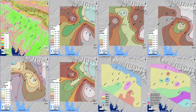
This geospatial and analytical study integrates GIS techniques with survey data and laboratory analysis results to investigate soil mapping units, classify soils, and evaluate its development and capability for agriculture at the Sulaivani plain, north-west of Duhok city, Kurdistan, Northern Iraq. The analysis of 43 soil samples indicates that clay (156–551 g kg−1), total organic matter (15.24–47.03 g kg−1), total carbonate (168.34–319.84 g kg−1), and active carbonate (70–280 g kg−1) contents varied across the study area, with CEC values falling between 14.34 and 36.24 Cmolc kg−1. The application of the USDA-NRCS Soil Taxonomy (USDA-NRCS (2006) Keys to Soil taxonomy by soil survey staff. USDA. Natural Resources Conserv. Serv., Washington, DC) revealed that the soils within the study area, derived from limestone parent material, were predominantly Vertisols order, only pedon 5 was classified as Inceptisols order due to its underdeveloped state and contains only Ap and Ch horizons. The soils are generally well-developed with organic matter in an advanced state of decomposition, as evidenced by the ratios of carbon to nitrogen (C/N) (4.51–26.99), active carbonate to total carbonate (0.31–0.92), and total clay in the B horizon to that in the A horizon (0.55–1.45). Their classification falls within the Xererts suborder, Haploxererts and Calcixerets great-groups, with Typic, Chromic, Entic and Vertic subgroups. The analysis of 14 pedons revealed the presence of 5 distinct soil mapping units, with a significant promise for agriculture due to a combination of suitable topographic features, soil properties and prevailing climate. The findings of this study provide critical support for policy-makers aiming to improve sustainable agricultural productivity and monitoring land cover and its management of ecosystems.